Sunday, July 29, 2012

July 21: Maidens and Warriors


It was 95º at 10 a.m. (daylight savings time) today.  At 3:00 p.m. it was 104º and at 6:00, 106º.  We visited two sites and took lots of water in our canteen and backpacks.  In the evening, we cooled off in the overly air-conditioned county library and started working on setting up our blog and finding more sites to visit.

We hiked to sites on the west and east sides of Moab.  Neither site is generally known to tourists, although locals are probably well aware of them.  I have not seen either site represented in most scholarly records of rock art sites, except Kenneth Castleton’s 1970s survey.  We used GPS coordinates from an internet source to locate them.

The first site was back in Kane Creek Canyon.


  It required a climb up a steep slope on a side wash that was shaped like an amphitheater.


  I believe the setting was important.  At the top, near a prominent rock that can be seen and from which someone could be hear for a great distance,


 we finally found the rock we sought.


  It is called the Moab Maiden, although one cannot be certain about gender.  Who was she and what did she represent?


Again, like the Owl petroglyph site, this was not on any obvious trail.  Rather it was at the confluence of Kane Creek Canyon and the Colorado River.  It was also directly across from one of the great rock art panels in the area (to be presented later).

In the afternoon, we followed Mill Creek Canyon out of Moab proper.  Mill Creek comes down from Mt. La Sal and provides Moab with much of its water.  We had to cross the creek several times along the several mile hike.  Since it was 104º, the cool, wet feet were welcome.

We climbed a ledge looking for a specific set of petroglyphs.


  We did not find what we were looking for, but did find a number of peckings high up in the bluish desert varnish on the ancient red Wingate sandstone cliffs on the west side of the canyon.


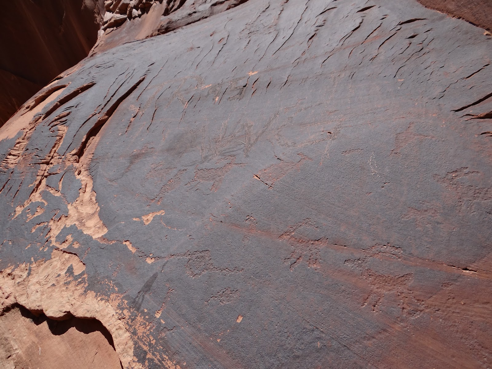
As we were returning, somewhat disappointed, I noticed two boulders on a ledge at the confluence of the north and south forks of Mill Creek.


  Knowing that confluences are often marked by “rock art,” we scrambled up the ledge.

There they were.


 Strange Fremont Indian style figures, perhaps warriors wearing ceremonial paraphernalia.  Birdlike.


  They were very ancient and weathered.  But still clear.  Three boulders were connected by lines and sheep and more strange anthropomorphs.


Saturday, July 28, 2012

July 20: Exploring Hidden Valley and Grand County


We did laundry today, got the Jeep’s oil changed, and went to library to work on setting up the blog and begin sorting through photos and field notes.

I did a little reading on Moab history and culture in the “historical” era.

As I mentioned earlier, Moab is in Grand County, UT.  Geographically, Grand County occupies about 3,700 sq. mi. of land.  That is more than four times as large as Berks County in Pennsylvania.  But only 13 sq. miles of that territory is water (.35%).

Meanwhile, the population of Grand County is less than 9,000.  That is smaller than the town of Wyomissing outside Reading.  Moab has 5,000 of those residents, not including the Spanish Valley--a “suburb” of Moab where we are camping.

According to the official Grand County website, the third largest city in Grand County is Cisco (seen in the film Thelma and Louise) which is a ghost town.  It is.  We were there last year.  This year we had occasion to drive 30 miles north of Moab to another ghost town, Thompson Springs, a stop on Interstate 70.  It used to be an Amtrak stop in the middle of nowhere (the “Book Cliffs”).  There were a handful of trailers and an abandoned motel, café, and “Souvenir Gift Shop.”  Official population:  39.

I thought that might help give perspective to the notion of isolation.  There were many more people living in southern Utah during pre-historic times than today.  They knew how to adapt to the environment, that is, before overgrazing, mining, and drilling remade the landscape in our own image.


I mention this because one of my operating premises is that the prehistoric petroglyphs should be studied in terms of the terrain and geography of each site.  I do not believe they are a set of symbolic writings that can simply be decoded.  No universal interpretation is possible.  One has to know how each group lived and how ancient Americans in this type of landscape related to it.  The landscape is what provided meaning, in my opinion.

This means that we often spend 2 or more hours at a single site, in some cases after hiking and exploring 3 to 4 hours to find or get to the site.  In several instances, we have had to return a second time (as we did with the Owl petroglyph) because we could not find a trail up the canyon wall to get to it.  (Yes, we are careful.)

Yesterday, we climbed up the Moab Rim


 to the west of our campsite, about 500 feet in elevation straight up over boulders.


 On the top is a two-mile valley that is an old Anasazi trail through the “Behind the Rocks” wilderness of slot canyons.


Last year we could not find the petroglyphs that we were told were up behind the Moab Rim.


 We were surrounded on two sides by hundred foot cliff-faces that stretched for four miles.  We finally found a one-foot wide trail through the cyrptobiotic soil leading to a large rock formation that we had to climb.  There we found the panels, spread about 600 yards along the face of the cliff.  The row of Bighorn sheep was especially impressive.


Again, the detail of the pecking was noteworthy.


  Two figures to the side seem to be fighting.


Other figures seem to be dancing or in a trance (shamans?).


We will probably return when it is cooler, now that we know the location.  We may find additional panels further along the cliff.

By the way, cryptobiotic soil


is desert ground covered by living organisms (lichens, fungi, molds, etc.) that help hold in nutrients and moisture.  It takes 150-200 years for the soil to mature (so they say).  I was particularly fascinated by the “gardens” of cryptobiotic soil growing in the depressions of the slickrock on the Moab Rim.


  It is a sin to step on cryptobiotic soil.  Bumper stickers in Moab read:  “Don’t break the crust.”  But it does make exploration of this area more difficult.

July 19: More about petroglyphs


My error of omission:  I should have put yesterday’s petroglyphic images into a better context.  I do take extensive field notes on each site, so I have no excuse.

The Owl petroglyph is about 3 feet tall; the Fremont figure next to it is about six feet tall.  Both are on a cliff face about 300 or 400 feet above the canyon floor above a ledge about 3 feet wide.  They were above my head, 10-15 feet above the ledge.  That meant that the ancient “artist” had to stand on a ladder to produce them.  (Were others holding the ladder and tools?  Chanting?)

My guesstimate on the bear petroglyph is that it is 54 inches across.  (I was climbing a narrow ledge to get to it.  No, I did not take a yardstick with me.)  The little men with bows and arrows “hunting” it (if that is what was intended) were at most a tenth the size of the bear.  That’s animal respect.

The Birthing image was about 5 feet long on a very large boulder with surrounding images on all four sides.

By contrast, the little bird-man image we sent was only 6-8 inches tall, despite the incredible detail of the figure.

You should notice that these images, like most in the Moab area, are fully pecked (or chiseled).  That takes a lot more artistic effort than simply scratching an “outline” of a figure, as one founds at so many other petroglyphic sites in New Mexico and Arizona.

You should know that the images were produced by a “hammer and chisel” method (a hammerstone against a hard, sharp stone—these were neo-lithic peoples).  It takes a lot of skill to produce such images with precise lines and very even “pecking.”  The big figures took hundreds, if not thousands, of precise and evenly delivered blows.  We have photos of many weathered petroglyphs that are so faint as to barely be seen.  Yet the circular chisel marks are clearly visible when one gets within inches of the surface.


 (Taking rubbings of such marks is a strict no-no.)

This was not a “trail” since the ledge fell off a hundred yards later.  Why go to such efforts?  I will share my hypotheses at a later time.


Friday, July 27, 2012

July 15-18: Discovering petroglyphs and pictographs


Yesterday we hiked a couple of miles on a trail off Kane Creek Road about 4 miles west of Moab.  The road follows the Colorado River through the “Portal” entrance into Canyonlands and “Behind the Rocks” wilderness areas, before turning up Kane Creek Canyon.  This is a long canyon that is part of the Colorado River drainage.  An unpaved road runs up and then down the canyon for at least 20 miles.  The road has no guardrails and is sometimes a single-lane.  Glad we have four-wheel drive this time.

We returned to this area again and again over the first two weeks because it is rich in hundreds of rock art sites.  Some sites are well marked, but others required some digging in obscure books and internet sources.  We became members of the “Climb Utah” and the Utah Rock Art Research Association to help provide us with suggestions and directions.  Even with directions, finding trails and locating sites is not an easy proposition.  At least our GPS and compass help us to avoid getting lost.

One set of petroglyphs often means that there are others nearby.  So we explore nearby canyon walls with binoculars.

As we approach each panel of ancient petroglyphs, we keep in mind that many of these sites may have been quite sacred.  Even if other sites may have had more pragmatic functions, they put us directly in touch with the mind and imaginations of an ancient civilization.

The precise manner in which the petroglyphs and pictographs were made indicates that they were important to their creators.  Some rock art is mere doodling.  What we are finding is a form of graphic art that was meticulous, creative, expressive, and required technical skill.  Some of these panels are hundreds of feet long and twenty feet above ground level in inaccessible (to us) places.

On these three days along backcountry trails we found a number of unique figures.   The ones we will initially share with you are:  “Moab Man,” the “Mastodon,” the Owl, the Freemont masked figure, the “birthing rock,” and a couple of typical Bighorn Sheep.  First, the sheep:


We have seen a great variety of Bighorn Sheep petroglyphs--rectangular bodies, fat bodies, stick legs, thicker legs, horns set at different angles.  The number attests to their importance in the cultures.


Is it really a “Mastodon/Mammoth”?  That would be 10,000 years after their extinction.  Although they once roamed this landscape, as had the dinosaurs, could a memory or image still reside with the Anasazi people?  Strange in any case.


The “Owl” required two separate visits to locate, as we could not pick up the trail the first time.  We had to do a lot of climbing up the cliff face.  I do not believe there is any other similar petroglyph anywhere else.

Moab Man is what is called an “anthropomorph.”  There are thousands of these sorts of figures in Utah, but no one figure is like any other.  Sort of like snowflakes.  And the image persists over centuries of rock artistry.  Are they humans, imaginative beings, masked ceremonial leaders, shamans, or what?  Part of the puzzle.


Moab Man is an Anasazi (ancient Puebloan) figure that welcomes people to Moab.  (Actually, he and his companions overlook the Moab Golf Course in the Spanish Valley.  Perhaps they were Leroy Neimanesque duffers or simply spectators waving at the golfers below.)


The austere Fremont masked figure is from a different cultural group and is next to the Owl.  No one knows what the connection is.


Finally, the “Birthing Rock” is an ancient and weathered figure on a boulder along Kane Creek Road.  There are petroglyphs on all four sides of the boulder.  Whether this is really a birthing scene and what it might mean is another puzzle.  But it is unique.


I threw in the strange birdlike creature and the huge “bear” petroglyphs as extras.  Notice the three hunters with bow and arrow aimed at the bear.  Hunting was a group activity, involving lots of time “on the road” and dangerous.


July 15: Plans and first hiking


Thank goodness for the Grand County Library.  Library Journal named it “the best small library in America in 2007,” and it is pretty good in 2012.  It has a great WiFi network and all the free access we want.  It also has a great collection on Utah history and archeology, which is helping us plan our trip.

We have tentatively decided to divide our “rock art” investigation into four geographical segments.  We will start in the Moab area, because it is rich in sites from 2,000 B.C. to 1200 A.D., and familiar to us from last summer.  Second, we will travel north to Nine-Mile Canyon and Vernal, Utah (Dinosaur National Monument), with a rich collection of Fremont Indian rock art from 600-1200 A.D.  The Canyon Road alone has over one hundred “sites,” with anywhere from 25 to a couple hundred figures per site.

The third leg will be the “San Rafael Swell” and Capitol Reef area to the west of the Green River—a very wild area, notable, among other things, as the hide-out for Butch Cassidy and the Sundance Kid (in “Robbers’ Roost”) and Aron Ralston’s misadventure in 127 Hours.

The fourth leg will be the San Juan/Grand Gulch region south of Moab and east of Glen Canyon/Lake Powell.  (Lake Powell essentially putting Glen Canyon and its extensive archeological record under water.)

The last two areas will likely involve some wilderness camping.  And that is another reason to put them last, as we consider what is essential and what we can leave in Moab.

We explored two sites today, one involving some distance, but no climbing.  (Actually, we do not really rock climb; we rock clamber.)  We need to accustom ourselves to the heat, not merely the temperature but the heat radiating off the barren sandstone rocks and cliffs on which we have to climb.

Janet got a slight case of heat sickness today, but we had lots of water and took it easy.  She has felt better on succeeding days.  Janet accompanies me on every expedition, at her own insistence.  The only times I (Bill) go off on my own is when I want to explore further off the route and do not want Janet to use up her energy reserves.  So, while I wander in search of hidden petroglyphs or trails, she sits and eats Slim Jims or Beef Jerky, which she likes.

We have encountered neither rattlesnakes nor mosquitoes.  The only fauna we frequently confront are lizards.  These lizards are 3-4 inches in length as adults.  They scramble up rocks vertically like Spiderman and come out of crevices like Batman.  Although they scamper away when we walk by them, they seem to watch us with fascination as we gaze at the rock art and take photographs.  Maybe they know much about the petroglyphs we are looking at but won’t talk to Anglos.  I have grown fond of them and call them “Lizzie.”

I hope our photo attachments come through.  The first is mom the adventurer at various sites over the last 10 days.  The second set is Lizzie.


Wednesday, July 25, 2012

July 14: Moab and our campsite


Arrived in Moab in early afternoon.  Moab will be our focus of operation for 2 weeks or so.  The area is rich in “rock art” (a debatable categorization), some requiring considerable exploration and canyon hiking.  Moab also has a great modern library (the only one in the county) and a BLM regional headquarters that will provide us with local information not available to tourists.

The relatively inexpensive KOA campground is luxury that we will take advantage of as we plan our itinerary.  Moab is also the only “city” SE Utah and has excellent stores and facilities for car maintenance, laundry, etc.  Moab is a place for tourists and adventurers.  The town itself has 5,000 residents, but also has 1.6 million visitors during the summer and fall months.

As soon as we finished setting up our tent, it started to downpour.  The weather service says Moab only gets .54 inches of rain in July, about 8-10 inches for the year.  Just our luck, it has been stormy almost every day we have been here.  About .25 inches the first day and at least a half-inch a few days later.  It rained again yesterday evening around suppertime.  Rain on the Colorado Plateau in the summertime is like a “monsoon.”  It comes up quickly and violently and then subsides.  Our tent was set up well to handle the wind gusts, rain, and blowing sand.

Temperatures have ranged between 95º and 105º during the day and in the 60s and 70s at night.  Janet and I try to plan our hikes in the morning because the sandstone rocks in the canyons are like a kiln by the afternoon.  We take several gallons of water with us, as well as protective clothing, wet neck scarves, granola bars, peanuts, and beef jerky.  Our walking sticks have come in very handy, as we often have to clamor over rocks or traverse slickrock surfaces.

If we can get pictures on Janet’s blog, you will see that our campground in Moab is located in a valley between the “Moab Rim,” that rises about 600 feet to the west, where the wild canyons begin, and the La Sal Mountains to the east, about 3-4 miles from us.  The La Sal Mountains are the second tallest range in Utah; Mt. Peale, one of a dozen peaks, is over 12,700 feet.

When we leave Moab, we will miss the international flavor of the campground and City Market.  So far our neighbors have been German, Austrian, Dutch, French, English, Korean, inner-city teenagers, and Mormons.  Almost all come for one or two days to see the national parks and scenery, although a few young men come for the mountain biking and canyoneering.

Our future entries will tell a little bit more about our hikes and search for obscure prehistoric American Indian petroglyphs and pictographs.
Here is our site at the KOA in Moab.


This is the view of the La Sal Mountain range from our site.

The unusual cloud cover is obscuring the mountains beyond Moab.

The early sun reflects on the Moab Rim across the road from our campsite.