Monday, August 27, 2012

August 26: Bear Essentials


Good weather today.  Not a dark cloud in the sky.


We drove back across Comb Ridge to Cedar Mesa, in part because we wanted to check out the campgrounds at Natural Bridges National Monument, near Lake Powell.  It would make a possible residential location while we explored the Cedar Mesa canyons in the future.  And it would only cost us $5 a night, as seniors with a "golden pass."  They even have flush toilets and a water source!  But no showers.  No hot tub either.

This was a day of ruin rumination.  We will try to pick out some curious features we saw.

Five Kiva ruins


outside Blanding is a curious place,


not merely because of the five kivas in the alcove,


but because it is the party hang-out spot for Blanding teenagers.

In Butler Wash we hiked to an overlook on ruins that occupied several levels of alcoves.


The BLM provided us with a nice overview.


It took binoculars to look into the site.


What was just as interesting was the "Moki steps"


that the Anasazi residents used to climb into the settlement.


We decided not to use the steps.  In fact, the slickrock we used to get to the overlook was quite comfortable hiking.


All the way to Natural Bridges N. M. we were in the shadows of what the Navajo call the "Bear's Ears."


These can be seen from as far away as Mesa Verde in Colorado.  The Navajo believe they can cause people to become ill and depressed but that they also have curative sacred powers.  The story of the Changing Bear Maiden, who was the source of the Bear's Ears, is still told during the Upward Reaching Way ceremony of the Enemyway Chant by Navajo holy men.

To be brief, the beautiful young woman was tricked by Coyote into marrying him.  But while he continued to philander, she turned into a self-centered, insensitive woman, who began to transform herself into a bear (a very powerful animal with healing properties for the Navajo).  She ended up killing all but one of her 12 brothers--being basically bear-minded.  But the last brother killed her, distributing her body parts across the landscape.  Her ears landed on Cedar Mesa and are still visited by the Navajo.  I was just glad to be able to pronounce "Bear's Ears" correctly.

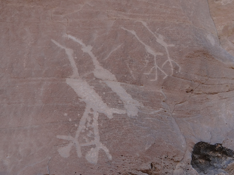
We stopped at the Ranger Station to check up on regulations.  They nicely told us to keep everything secret.


They also explained the source of pictograph colors, for those of us interested in the fine arts.


Or chemistry.

We got to Natural Bridges in mid-afternoon, which ruled out doing any canyon hiking.  We had to be content with the National Park Service provided overlooks.  There are three huge natural bridges, largest in the world except for Rainbow Bridge in Glen Canyon.  But the natural bridges here will soon be on top since the foundations of Rainbow Bridge are rapidly being eroded away due to their immersion in Lake Powell.  Recreation has its price.

(By the way, the difference between a natural bridge and an arch is that a natural bridge is formed by running water; an arch is formed by sitting water.  Compared to natural bridges, arches are couch potatoes.)

We love the curves and forms of Sipapu Bridge.


It is part of the serpentine White Canyon


that runs from Glen Canyon deep into the interior of Cedar Mesa.  More on White Canyon later.  There used to be towns and ranches in White Canyon, before the Glen Canyon dam was built.  There were also fantastic and irreplaceable rock art and ancient Barrier Canyon, Basketmaker, Anasazi, and Fremont villages in Glen Canyon. There was no time for archeologists to do more than take pictures of surface structures and take notes to be deposited in museum archives.

The most graceful natural bridge was Owochomo, some 260 feet across and only nine feet of Cedar Mesa sandstone thickness.


While we admired it from a distance, two ravens flew down the canyon and landed on the bridge.


Some sort of mating ritual.  I like the shot, even if it invaded their privacy.

Next time we visit, we will be hiking down and up canyons.  There are petroglyphs and ruins down there.  One ruin is called "Horsecollar Ruin,"


due to the odd shape of the windows on the granaries.


An unusual feature was the rectanguar kiva,


as opposed to the circular kivas we have seen so far.  This is a "Kayenta" kiva,


showing northern Arizona influence rather than Mesa Verde influence.  Two young people were in the process of climbing the ledges to view the ruins close up.


I think the guy was having trouble convincing his wife to join him,


although she had on some really chic hiking gear.  (I did not take a telephoto shot of her, thank you.)

We probably will come back here to camp as the temperatures cool.  $5 will hardly be our ruination.

August 25: Canyon Exploration


The great thing about car camping is that we get to eat out every night, on a picnic table.  But after a day of hiking, or automobile bouncing, we sometimes like to eat in.  Blanding has two choices:  the Subway or the A & W.  Last night it was Subways for dinner; root beer floats for dessert.  A lot of Navajos patronize Subways.

What they cannot do is buy beer or any other alcoholic beverage.  Blanding is dry, whether due to its Mormon population (there is only one church in town) or to the problem of reservation alcoholism.  Root beer is OK, though.

Today we drove over the local geological wonder, Comb Ridge, to hike in the Cedar Mesa area.  Comb Ridge is a massive, 100-mile long "anticline" running from the San Juan River to the Abajo Mountains.


It was pushed up millions of years ago by underground pressure, as were the Moab Ridge and the San Rafael Swell further north.  Driving over it and around it is a spectacular visual experience, in which the ancient geology of the earth is opened up with surgical precision.


Anasazi and Navajo mythologies attribute "snake-like" qualities of life and death to the Ridge.

We briefly stopped at a wayside exhibit that nicely showed what an early Anasazi unit pueblo would have looked like.


The kiva was open to allow tourists to see clearly the ventilator shaft, deflector rock, fire pit, and sipapu--as well as how a "Mesa Verde-style" kiva was constructed.


Then we drove over half a road to the south fork of Mule Canyon


and parked on what looked like a stable place.  This is not a difficult canyon to hike, and we did not get quite as far as we wished.  Shucks.  I was carrying water and supplies in our backpack, and Janet was a little under the weather.  But we did make 6 miles in 4 hours.  (Not the 2 hours our informant had told us.)

However, we were rewarded with the sight of ancient granaries high on the cliff face


and some colorful flowers along the way.


Apparently, horse flies also like colorful flowers.  Since it had stormed recently, the creek we kept having to walk through was quite wet and muddy.  So were our shoes.

High on the south-facing cliff face were Pueblo III cliff dwellings.


This one had a wall to keep residents from falling.  We climbed part way up to see it, but the last 50 feet were a bit daunting and I was content to use my telephoto settings.


The prize, however, was an ancient pueblo ruin that we could reach.  Hikers and photographers usually call it the "House on Fire" because of the flame-like pattern of the cave's ceiling.


We did not actually climb in or disturb anything, trying to be good explorers.


But being this close enabled us to admire the workmanship of these ancient people, such as the care they used to construct their windows and doorways


--techniques we still use today.

We also had a bonus.  We continued to walk around the edge of the cave and between a couple of huge boulders.


It was clear that there were once rooms hidden under the boulders and storage facilities on the other side.  But coming back through them we immediately looked up and spotted handprints over the boulder entrance.


These are not unusual pictographs at Anasazi cave sites, but none of our sources had mentioned these ancient statements of ownership.  Or are they statements of being connected to the canyon?  These were canyon people.

August 24: The Montezuma Valley


We found an inexpensive campsite in Blanding that turned out to be very nice.  Not only did we have grass on which to pitch our tent,


but really hot showers.  Best of all, there were few other campers, which meant that we had the recreational facilities all to ourselves.


Blanding is at the foot of the sacred Abajo Mountains.  It continued to be stormy, but we decided to venture forth today anyway.


We headed 40 miles west, toward the Colorado Border, on back roads.  Our destination was the Hovenweep Ruins site.

This is Navajo country, and we even passed a red bus that was part of the Navajo Transit system.  It brought Navajo children from the reservation areas into Blanding for school.  We have met many Navajo children in the Blanding library while we are blogging and they are using computers in an after-school program.  We even passed a Navajo hogan and ceremonial center on our way to Hovenweep.


And we stopped at the Hatch Trading Post, which has been bartering with the Navajos for over a century.


Hovenweep was better than we expected and has inspirational qualities.


The National Park System only runs one of six sites, and we only had time to visit this one.

Some background:  Hovenweep is located on what is called the Sage Brush Plain that runs from Blanding all the way over to Mesa Verde in Colorado.  Even today, it is a fertile area in the Cortez, Colorado, vicinity.


Between 1200 and 1250 this large region of canyons was inhabited by ancient Puebloan villages, each of which numbered in the hundreds of inhabitants.  It was a heavily populated area before it was totally abandoned by the Anasazi by 1280.  Mesa Verde was a relatively small settlement in comparison with places like Hovenweep, Yellow Jacket, and Goodman Point, places we hope to visit.

Hovenweep was a complex of sophisticated masonry buildings surrounding both sides of the Little Ruin Canyon in SE Utah.


It must have been an impressive and imposing sight for visitors.  Large, multistoried buildings revealed a highly structured society.


These buildings were constructed both on top of the mesa and along the talus slopes on both canyon sides.  Tall, square towers served as defensive watchtowers.


Circular and D-shaped buildings had special ceremonial purposes, and also had small openings that kept watch against enemies.


Archeologists do not know who these "enemies" were, but they threatened to steal the wealth of the community, or possibly destroy it violently.

The masonry skill is every bit as impressive as masonry at Mesa Verde or Chaco Canyon.  Stones were carefully chiseled and fitted together, whether the buildings were square, cylindrical, or D-shaped.


Exterior and interior surfaces were pecked smooth.  Buildings could even be built into the boulders of the canyons.


From the canyon floor, the settlement (about 500 residents) would have spoken of the dominance of humans over the landscape.


Later that day, we took a backcountry road to return to Blanding.  We drove up the Montezuma Creek Canyon.  This valley was slightly east of Hovenweep.  Between 600 and 1250, it was heavily populated with early and late Pueblo settlements, though desolate today


--except for oil and gas drilling tanks and trucks.

The canyons are filled with hidden petroglyphs and ruins.


We stopped at one prominent site, with panels about 200 yards long.  Pueblo art was heavily weathered, but the probable fertility symbols were still evident.


Again, the artistry of the chippers was evident.


There was also a lot of evidence of later Ute rock art.  See if you can figure out why many of the figures in this panel could not be pre-historic, although some of the original images may, in fact, have been ancient puebloan.


We drove seven miles further up the dirt road


to a small ruins site, called Three Kiva Pueblo.


Its isolation and quiet held a definite appeal.  It was open to the public to explore--with care and respect, of course.


In its day, it would have been just one of many small pueblo household settlements in the valley.  Each had its own family or clan "kiva," made of masonry now rather than simply a pithouse.


The beauty of this site is that one can linger and imagine the human activities that must have gone on inside the kiva 1,000 years ago.