We arrived in Mesa Verde on the 29th and planned to visit Wetherill Mesa and Long House on the 30th, since that part of the park would be closed after Labor Day.
We set up camp in the park's campground

at the foot of Prater Ridge and the Lone Cone.

Each morning, we share the area with the park's deer

and an occasional coyote, one of which I almost ran over and was so disconcerted that I forgot to reach for the camera, for once. The skies greeted us in the morning with a "blue moon."

It reminded me that our wedding anniversary was coming up.
We had planned to stay at the park 2 or 3 days. (Most visitors stay less than one day.) But we have been at Mesa Verde for 10 days now, in part because it has made a convenient and cheap center for exploring the region and in part because we needed to find dental services in Cortez. As old fogeys, we get into the park free and pay half the campground fee, which amounts to under $15.
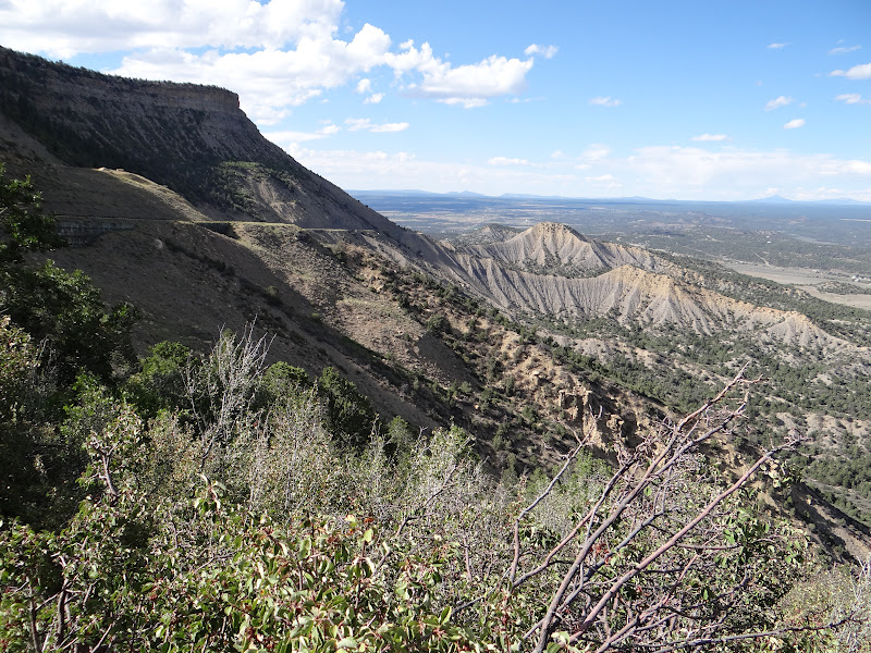
The escarpment of Mesa Verde is much more imposing than I imagined.

The north side must be around 15 miles long and very dramatic.

But Mesa Verde is not really a "mesa"; it is a "cuesta." Look it up yourself. Ok, that means it gradually slopes southward to the Mancos "River," which cuts through its southern portion (in Ute territory).
The mesa (cuesta) top itself is really like a series of fingers on a hand. It is cut by canyon after canyon. Only one road, built in the 1970s, runs across the north end and connects each fingerlike mesa within the total uplift.

From the top, one sees the LaPlata Mountains to the east

and the Sleeping Ute Mountain to the west.

Yes, these are sacred mountains to the Navajo and Ute Indians and connected to their mythologies and identities. I may get around to talking about that.
The road leading up from the entrance rises some 1500 feet.

While it is dramatic, it is nowhere near as dramatic and scary as the pre-1950s old road up a precipice called the "Knife's Edge."

It was a single lane dirt road with a ditch running alongside to catch vehicles before they plunged downward. Many who drove Model T's and Chevies up needed to hire drivers to bring them down!
But even with the new road,
the park service spends enormous sums on road maintenance because the only road in and out of the park is built on the Mancos Shale geological layer that serves as the base of the mesa.

Mancos shale is like sand; and after a rain, mud and boulders come tumbling down. One year 150,000 cubic yards of mud and rock closed the road after a storm.

Large trailers are prohibited from driving the roads, probably because the road itself might slide away.
The ancestral Puebloan peoples who populated the mesa from the 600s to the 1200s made high-quality ceramic pottery out of this Mancos shale. They used it as temper, mixing it with local clays to produce distinctive Mesa Verde Black-on-White pottery, which they could than use to trade over a large region in the Four Corners area. Janet and I already saw much of this pottery at the Edge of Cedars Museum in Blanding.
The views over the mesa top are lovely,

especially since the yellow rabbit brush was in full display.

However, fires have ravaged the park over the last 20 years, mostly caused by drought and lightning.

Over 40% of the park has been hit, including historic archaeological sites.

What is coming back in many areas is Gambel Oak shrubs.

The old Utah Junipers and Pinyon trees that were so vital to the eco-system and ancient human habitation are gone. We were surprised to learn that it takes more than 100 years for a Utah Juniper tree to grow to maturity.

We saw one growing in a fire-devastated area that was about 12 inches high. The ranger indicated that it had started growing in the late 1990s.
That information gave us a new appreciation of the role of juniper/pine forests in the cultural history of the ancestral Puebloan peoples. It also caused us to be even more amazed at the plethora of old, gnarly Utah Junipers we have seen growing out of sheer rock in the arid deserts of canyon country.
By the way, the park service refuses to use the term "Anasazi," since they feel it is politically incorrect. However, a park ranger did admit to us that it was a lot easier to say than "ancestral Pueblo." Indeed, during our visit to Cliff Palace, one young father stumbled over the term "ancestral Puebloan" and ended up asking the ranger about ancestral Pavlovians. Ah, a college psychology major, Janet noted sympathetically. He's just being a dad, I thought aloud.
Today, we toured Wetherill Mesa, Long House, Step House, and Spruce Tree House.
The scenery is AMAZING! How does one turn around on the Knife's edge?
ReplyDelete