Having driven 150 miles to Durango for Janet's follow-up visit to the oral surgeon, we were pleased that he saw her right away. Her check-up took about 5 minutes, which I figured worked out to 30 miles per office minute. The important thing is that Janet is fine and has started to feel stronger and more chipper.
On the return trip to Utah, we passed through Cortez again and sent some blogs, finding out some additional information on Marietta Wetherill, Richard's wife, who left 2,000 single-spaced pages of oral transcripts in the early 1950s.
Heading for Blanding, Utah, we decided not to take the "fast" route through Dove Creek pinto bean fields. Instead, we took the scenic route down the McElmo Canyon ("Road G"). Glad we did. This was the route that the first expeditions took when they found Anasazi ruins, like Hovenweep. This was also the route that the Wetherills took on their expeditions into SE Utah.
It is a beautiful canyon that skirts the northern edge of Sleeping Ute Mountain. All the McElmo canyon systems drain into it. It was obviously a fertile valley a thousand years ago, before the McElmo Creek deeply entrenched itself into the soil.
We passed several boulders with petroglyphs on them. Then, on a hunch, I turned up a dirt road at the mouth of the Yellow Jacket Canyon. This was the location of an old trading post known as Ismay. Sometimes these trading posts were located in strategic spots. Besides, this small area was included in the Canyons of the Ancients National Monument, and there is always a reason why certain areas have been turned over to BLM jurisdiction. No one will publicly reveal what is in these areas; the point, you remember, is to be a discover-it-yourself hiker.
Fortunately, a weathered sign marked the road we needed to turn down.
A broad canyon valley opened up.
The Hovenweep and Yellow Jacket canyons were coming together here and merging with the McElmo Canyon.
Location, location, location.
Janet and I wandered up and down the hills and between boulders looking for a petroglyph panel I suspected was nearby. We could not find it.
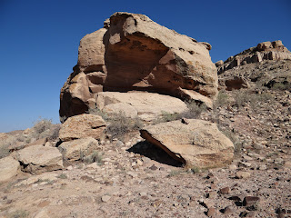
Looking closer at the boulders that surrounded us, we suddenly felt very silly. All around us were ancient granaries built into the nooks and grannies of virtually every boulder.
In some cases, the blocks of stone were visible.
Some were quite large.
In most cases, the stones were still covered with ancient mud/adobe.
These were obviously not made by "nature" but by human construction.
They had small openings that could be sealed against rodents, birds, and invaders.
The entire area was a granary reserve. We saw evidence of possible residential structures as well,
although these were likely just temporary campsites.
But we missed locating the petroglyphs. Rather, we almost missed. I was determined to find them, but finally realized we had to get to Blanding before dark.
As we began driving out, I spotted a boulder on the driver's side of the car that had the "marks" of a petroglyph site.
It had a "theatrical display" shape and was located at the junction point of the canyons.
Climbing up the hill, it did not take long to see that this was it.
We nearly drove right by it.
There was no path, and so we climbed carefully. A large panel appeared behind a large boulder in front.
It was about 30 feet long and was marked by four lines that ran the entire length of the panel and crossed over to a side panel containing a spiral.
We got a good look at it because it faced west (unusual). That might have been related to the spiral, since they often measure movements of the sun.
Anasazi anthropomorphs walked along the lines.
But several features were unusual. Above the main panel was an interesting insectlike figure flanked by rows of vertical dots.
Dots again. A large horned serpent hovered over the whole scene.
A series of four triple spirals followed along the top line.
We had never seen triple-connected spirals before.
But the most exciting part of the panel was the initials, carved off to the upper left.
John Wetherill, Richard's brother, guided tours through the McElmo Canyon in the 1890s. These are his initials. We saw identical ones at Spruce Tree House in Mesa Verde.
It turned out that the backside of the boulder in front also had carvings--though these would have been invisible to passersby.
One anthropomorph had some strange physical attributes.
Serpents again. A mountain sheep seemed in motion.
(I had to include this photo since I was forced to take it blind.)
What startled us the most, however, were the ruins under the petroglyph panels.
The BLM has left them there. Nothing has been excavated. Behind the boulder with the petroglyphs were the outlines of a pit structure.
The walls of the structures are still quite visible.
The foundations of another roundish structure was adjacent to it.
It did not look like a granary foundation.
Could this have been a watchtower site? I envisioned young warriors camped here to protect the granaries that their people needed in hard times. The view was 360º, in all directions down all three canyon systems. Were enemies or raiders a concern? The Castle Rock Pueblo we visited earlier is only 10 miles further east along the McElmo. They certainly were worried about security, though it did them little good. As I climbed higher up and looked down at the petroglyph boulder, I could see the remains of a structure that had been built on top.
This was more than a highway billboard. It was a guarded site.
A nice day.


No comments:
Post a Comment