Today we drove 100 south to Bluff, Utah. Note the date that the "city" was established!
(I am not sure that there are 650 people living in Bluff.) It is a bucolic little resort town.
The date on the welcome sign is very interesting. For over a century, Bluff was proud of the fact that it was "settled" by Mormon pioneers who spent six months crossing the canyons of southern Utah (and the Colorado River) to create a Mormon outpost. They called it the "Hole in the Rock" expedition; and Mormons are justly proud. (We barely avoided having to sit through a documentary video on it in the Visitors' Center, which is rebuilding the early settlement as a Mormon destination.)
By using the 650 A.D. settlement date, Bluff residents are embracing recent archeological discoveries (1980s) that proved there was a major Basketmaker III settlement in Bluff. There are few BM 3 settlement sites in the Southwest. The state of Utah ran highway 163 right through the middle of one of the best. But at least the highway department gave archeologists a few months to find out what they could before the road graders came through and did their level best. Now Bluff is proud to advertise its Native American roots, in distinction to the historical marker we read nearby, left by the sons of the pioneers, that explained the first "white" settlement.
Anyway, this is a very interesting town on the edge of the White Mesa Ute reservation to the north and the vast Navajo nation to the south. Monument Valley is but an hour's drive away. It is on the San Juan River, which is the major waterway through northern ancestral Pueblo lands from Colorado, through northern New Mexico and southern Utah, on its way to its marriage with the Colorado River. (The Green, San Juan, and Little Colorado rivers are the major tributaries of the Colorado--though I hate to leave out the aptly named Dirty Devil River from the Grand Staircase/Escalante region.)
The presence of existing American Indian cultures cannot be escaped in Mormon Bluff, not least because of the many (very nice) trading posts.
We found an idyllic campsite in the "Cadillac" RV Park, by ourselves next to a fishing pond and under some old Cottonwood trees.
The presence of Cottonwood Trees and the all-pervasive Tamarisk shrub is a tip-off that Bluff is located on a fertile plain along a bend in the San Juan River.
Good thing, because Bluff only gets 7.5 inches of rain a year. Unfortunately, it all comes on a single day, it seems. Flash flood warnings have been posted since we arrived. (Could it be that Janet and I are the rainmakers?) But that is a story for tomorrow's blog.
We took advantage of the afternoon to visit Sand Island, which has primitive campsites for $5 (for seniors)--that we avoided--and very old petroglyphs--that we did not.
This required no hiking, for a change; but it was hot anyway. Again, we were in a "bowl" type environment in open sun.
The panels extended for at least a quarter mile.
The earliest, supposedly, go back to Basketmaker II cultures about 500 B.C. These show what is called the Glen Canyon Linear style, a variation of the Barrier Canyon style, according to some rock art academics (rock heads?) Note the elongated figures and abstract patterns on the garments of some anthropomorphs.
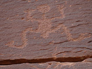
We were amused by the walking "ladder man."
We had seen him further north, too.
The Basketmaker images have weird curved antennae above their heads.
I do not think anyone yet has a good idea what they mean. The images of plants, probably corn, suggests later Basketmaker III culture, that began experimenting with corn cultivation.
Remember that a BM 3 village was found less that 2 miles from Sand Island.
Once again, we saw evidence of a face mask, or--more likely--a full-face head scalp.
We saw this image with the later Fremont culture that also began experimenting with corn cultivation. Since the Basketmaker II/III culture may have gone north and blended with the emerging Fremont, these images begin to put pieces of a prehistoric puzzle together.
The images of "lizard men"
are reminders of the later Pueblo cultures.
The Sand Island site is particularly noted for its striking Kokopelli images--again, associated with the cultivation of the earth, the need for rain, and, of course, fertility. Most of the images are too X-rated to show over the internet.
So I won't. Except to note that the Utah State Museum in Blanding, 25 miles north of Bluff, called Edge of Cedars uses a Kokopelli sculpture as its logo.
It also has Kokopelli images from rock art sites in Utah on display along its staircase.
However, these images are part of their educational outreach program for elementary/secondary students and Mormon boy/girl scout programs--not intended for bloggers.
I mean, seriously, who could resist the mountain sheep Kokopelli pecked into the cliff walls along the San Juan River at Sand Island?
Is that a female sheep leaping to his tune?
Anyone who suggests that these are simply "clan" symbols has no sense of humor, or imagination. Or rhythm.
I cannot finish without mentioning that we wandered far down the cliff face and came across additional images. But we were not sure about one place that looked like a "display" setting that should have images. We were probably engaged in wishful thinking, but we were sure we saw faint colors and outlines of Barrier Canyon forms on the smooth rock face.
Not proof. But what if the site goes back before 500 B.C.? What if the site could prove a connection between Barrier Canyon and Glen Canyon Linear style rock art?


Hmm..
ReplyDeleteThose flute players:
A penis reaching almost to the knee..was he really hung or is it Artistic license?